


Descrizione di BackCountry Navigator XE: Outdoor GPS App (New)
Welcome to the next generation of a product for exploring the outdoors on your own terms, using offline topo maps and GPS on your smartphone.
You can also subscribe to the XE List to get notified of status, updates, and deals.
While many of the goals of the new app are the same, we are hoping to achieve a number of goals with the new platform:
Cross-Platform
The original BackCountry Navigator PRO is only available on Android. We will be bringing BackCountry Navigator XE to Android, iOS and the web.
The corresponding app for iOS will be launched through TestFlight
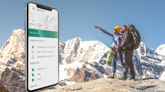
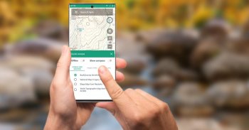
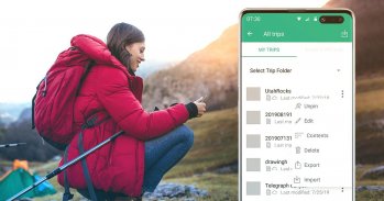
Planning In The Cloud
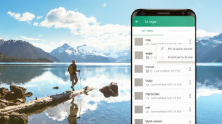
The website bcnavxe.com is the web interface for BackCountry Navigator XE. With it you can plot points, routes, and boundaries for trips, and download them on demand in the mobile app. You can push trips created in the mobile app to the cloud as well for reviewing or sharing.
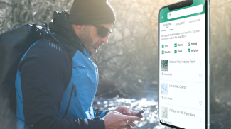
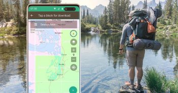
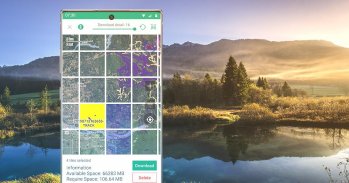
Easy Grid Based Download of Maps
You can try out a simpler approach for downloading and organizing offline maps, choosing large squares at a time. Visualize what you have and what you need.
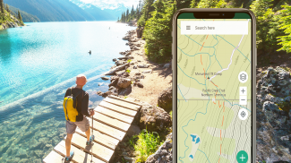
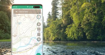
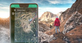
Vector Topo Maps for the World
Vector topo maps for the world hold the promise of crisp multilevel detail, with the ability to download large chunks of the earth's surface in a quick, compact operation. The BackCountry topo map for the world can be viewed in this app and on bcnavxe.com, with an easy process to install them in large blocks.
SALE: 5 and 10 year plans now available for a limited time at bcnavxe.com.
Use coupon SUB2020 to save even more before the end of the month.
If you are looking for an already proven and established product, also consider BackCountry Navigator PRO. Support and development of that app continues on a parallel track.
https://play.google.com/store/apps/details?id=com.crittermap.backcountrynavigator.license
Benvenuto nella prossima generazione di un prodotto per esplorare la vita all'aria aperta alle tue condizioni, utilizzando mappe topografiche offline e GPS sul tuo smartphone.
Puoi anche iscriverti all'Elenco XE per ricevere notifiche su stato, aggiornamenti e offerte.
Mentre molti degli obiettivi della nuova app sono gli stessi, speriamo di raggiungere una serie di obiettivi con la nuova piattaforma:
Cross-Platform
Il BackCountry Navigator PRO originale è disponibile solo su Android. Porteremo BackCountry Navigator XE su Android, iOS e Web.
L'app corrispondente per iOS verrà lanciata tramite TestFlight
Pianificazione nel cloud
Il sito web bcnavxe.com è l'interfaccia web per BackCountry Navigator XE. Con esso puoi tracciare punti, percorsi e confini per i viaggi e scaricarli su richiesta nell'app mobile. Puoi anche trasferire i viaggi creati nell'app mobile sul cloud per rivederli o condividerli.
Download semplice di mappe basato su griglia
Puoi provare un approccio più semplice per il download e l'organizzazione di mappe offline, scegliendo grandi quadrati alla volta. Visualizza quello che hai e quello che ti serve.
Mappe topo vettoriali per il mondo
Le mappe topografiche vettoriali per il mondo promettono dettagli nitidi a più livelli, con la possibilità di scaricare grandi blocchi della superficie terrestre in un'operazione rapida e compatta. La mappa topografica BackCountry per il mondo può essere visualizzata in questa app e su bcnavxe.com , con un semplice processo per installarli in blocchi di grandi dimensioni.
VENDITA: piani di 5 e 10 anni ora disponibili per un periodo di tempo limitato a bcnavxe.com.
Usa il coupon SUB2020 per risparmiare ancora di più prima della fine del mese.
Se stai cercando un prodotto già collaudato e consolidato, considera anche BackCountry Navigator PRO. Il supporto e lo sviluppo di quell'app continuano su una pista parallela.
https://play.google.com/store/apps/details?id=com.crittermap.backcountrynavigator.license
BackCountry Navigator XE: Outdoor GPS App (New) - Versione 2.8.1
(03-09-2023)BackCountry Navigator XE: Outdoor GPS App (New) - Informazioni APK
Versione APK: 2.8.1Pacchetto: com.crittermap.backcountrynavigator.xeUltima versione di BackCountry Navigator XE: Outdoor GPS App (New)
App nella stessa categoria
Potrebbe piacerti anche...


